Filter Results

Loading..

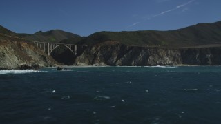
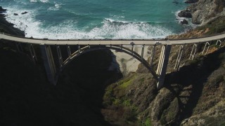
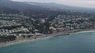
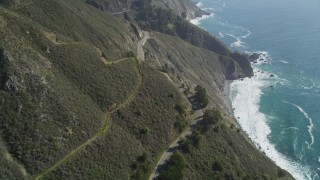
Highway 1 Stock Footage and Stock Videos - 130 Results

130 results of Highway 1 Stock Footage and Videos in 1080, UHD, 4K & 5K

Display
Thumbnails
Sort by
130 results found
DCLA_136 - 5K aerial stock footage tilt from Highway 1 to reveal beach in Pacific Palisades, California

DCLA_136

DCLA_137 - 5K aerial stock footage tilt from Highway 1 and beach to reveal hilltop neighborhoods near ocean in Malibu, California

DCLA_137

AX0160_052E - 7.6K aerial stock footage over beachfront homes and highway to approach Seal Beach National Wildlife Refuge, Huntington Beach, California

AX0160_052E

DCSF11_039 - Aerial stock footage of 5K Aerial Video Highway 1 with light traffic and coastal cliffs, Big Sur, California

DCSF11_039

DCLA_167 - 5K aerial stock footage fly over Highway 1 and homes on the beach in Malibu, California

DCLA_167

AXSF03_070 - 5K aerial stock footage bird's eye view of Highway 1 winding along hills above the coast, Big Sur, California

AXSF03_070

DCA07_175 - 4K aerial stock footage of bird's eye view panning across Highway 1, Pacific Palisades, California, night

DCA07_175

AX0156_166 - 7.6K aerial stock footage of light morning traffic on the coast, where Pacific Coast Highway meets Sunset Blvd, Pacific Palisades, California

AX0156_166

AX0159_228E - 7.6K aerial stock footage flying along beach near coastal highway, Newport Beach, California

AX0159_228E

AX0160_044E - 7.6K aerial stock footage of homes around an industrial area next to the beach and Hwy 1, Huntington Beach, California

AX0160_044E

AXSF03_088 - 5K aerial stock footage follow Highway 1 past Kirk Creek Campground, Big Sur, California

AXSF03_088

DCSF11_037 - Aerial stock footage of 5K Aerial Video Following the coastline, waves crashing into rocks, Big Sur, California

DCSF11_037

DCSF11_012 - Aerial stock footage of 5K Aerial Video Approach Carmel Bay and beach by Highway 1 by Carmelite Monastery, Carmel, California

DCSF11_012

AXSF03_075 - 5K aerial stock footage fly over a bend in Highway 1 in the hills above the coastline, Big Sur, California

AXSF03_075

DFKSF16_072 - 5K aerial stock footage of flying by coastal rock formation, revealing Bixby Creek Bridge, Big Sur, California

DFKSF16_072

DFKSF16_074 - 5K aerial stock footage of orbiting Bixby Creek Bridge above coastal cliffs, Big Sur, California

DFKSF16_074

AX0156_165 - 7.6K aerial stock footage of light morning traffic on Pacific Coast Highway in Pacific Palisades, California

AX0156_165

AXSF07_038 - 5K aerial stock footage tilt from bird's eye of freeway interchange to reveal Golden Gate Bridge, San Francisco, California, night

AXSF07_038

DFKSF16_115 - 5K aerial stock footage of flying over the Highway 1 coastal road and cliffs, Big Sur, California

DFKSF16_115

DFKSF15_090 - 5K aerial stock footage of tilting from the coastal beach revealing Highway 1, San Gregorio, California

DFKSF15_090

AX148_067.0000079 - Aerial stock photo of Small bridges, Highway 1 over river near rural homes, autumn, Thomaston, Maine

AX148_067.0000079

DCSF11_034 - Aerial stock footage of 5K Aerial Video Tilt up Highway 1 with light traffic above coastal cliffs, Big Sur, California

DCSF11_034

AXSF03_092 - 5K aerial stock footage of flying over ocean kelp to reveal small bridge on Highway 1 and cliffs, Big Sur, California

AXSF03_092

AXSF06_041 - 5K aerial stock footage fly over MacArthur Tunnel and The Presidio Golf Course, tilt to reveal Golden Gate Bridge, San Francisco, California

AXSF06_041

DFKSF16_003 - 5K aerial stock footage tilt from highway interchange, reveal US Naval Postgraduate School and coastal community in Monterey, California

DFKSF16_003

DCLA_139 - 5K aerial stock footage tilt from Highway 1 and beach to Malibu, California

DCLA_139

AX0159_211 - 7.6K aerial stock footage flying over coves and bay near coastal highway, Laguna Beach, California

AX0159_211

AX0160_046 - 7.6K aerial stock footage flying over Hwy 1 and beach to Bolsa Chica Basin State Marine Conservation Area, Huntington Beach, California

AX0160_046

DCLA_132 - 5K aerial stock footage fly over beach and tilt up Highway 1 in Pacific Palisades, California

DCLA_132

DFKSF16_116 - 5K aerial stock footage of flying over the Highway 1 road atop coastal cliffs, tilt to cars, Big Sur, California

DFKSF16_116

DCLA_178 - 5K aerial stock footage of passing neighborhoods near the beach and Highway 1 in Pacific Palisades, California

DCLA_178

DCLA_138 - 5K aerial stock footage tilt from Highway 1 to reveal neighborhood  on cliff in Malibu, California

DCLA_138

DFKSF15_152 - 5K aerial stock footage fly away from Fort Ord Dunes State Park, reveal Highway 1 coastal road, Moss Landing, California

DFKSF15_152

AXSF06_053 - 5K aerial stock footage of flying over coastal cliffs to reveal and follow Highway 1 at the base of mountains, Marin County, California

AXSF06_053

DCLA_134 - 5K aerial stock footage bird's eye view of Highway 1 and tilt to reveal hilltop homes in Pacific Palisades, California

DCLA_134

AX0160_043 - 7.6K aerial stock footage flying over the beach, Highway 1, and the oceanfront city of Huntington Beach, California

AX0160_043

DCLA_166 - 5K aerial stock footage fly over mountains to reveal and approach Highway 1 on the coast in Malibu, California

DCLA_166

DFKSF16_069 - 5K aerial stock footage of flying away from Rocky Creek Bridge above coastal cliffs, Carmel, California

DFKSF16_069

AX0156_144E - 7.6K aerial stock footage flying over residential toward beach and Pacific Ocean, Santa Monica Pier, Santa Monica, California

AX0156_144E

DCA05_103 - 4K aerial stock footage of flying by beachfront homes, Highway 1 along the coast, Malibu, California

DCA05_103

AX0161_082 - 7.6K aerial stock footage of office Buildings beside the Pacific Coast Highway in Santa Monica, California

AX0161_082

AXSF06_056 - 5K aerial stock footage of tracking a silver convertible traveling on Highway 1, Marin County, California

AXSF06_056

AX0160_049 - 7.6K aerial stock footage of the beach and Hwy 1 by Bolsa Chica State Marine Conservation Area, Huntington Beach, California

AX0160_049

AXSF03_079 - 5K aerial stock footage of flying over Highway 1 coastal road, and tilt to ocean waves, Big Sur, California

AXSF03_079

DFKSF16_076 - 5K aerial stock footage of flying away from Bixby Creek Bridge above coastal cliffs, Big Sur, California

DFKSF16_076

AXSF03_053 - 5K aerial stock footage approach Piedras Blancas Light Station from Highway 1 on Point Piedras Blancas, California

AXSF03_053

DFKSF16_068 - 5K aerial stock footage of flying over the Rocky Creek Bridge above coastal cliffs, Carmel, California

DFKSF16_068

AX0156_167E - 7.6K aerial stock footage of light traffic on Pacific Coast Highway on the edge of Pacific Palisades / Santa Monica at sunrise, California

AX0156_167E

AX0160_047E - 7.6K aerial stock footage of Hwy 1 and Bolsa Chica Basin State Marine Conservation Area, Huntington Beach, California

AX0160_047E

AX0161_073E - 7.6K aerial stock footage of office buildings by PCH and Ocean Avenue in Santa Monica, California

AX0161_073E

AXSF03_074 - 5K aerial stock footage of tracking a car traveling on Highway 1 along the coast, Big Sur, California

AXSF03_074

DCLA_163 - 5K aerial stock footage fly over mountain to reveal and approach Highway 1 in Malibu, California

DCLA_163

AX148_067E - 6K aerial stock footage of small bridges, Highway 1 over river, and rural homes, autumn, Thomaston, Maine

AX148_067E

DCLA_133 - 5K aerial stock footage tilt from bird's eye view of Highway 1 and beach by Pacific Palisades, California

DCLA_133

DCLA_161 - 5K aerial stock footage approach beachfront homes and Highway 1 in Malibu, California

DCLA_161

DCA05_099 - 4K aerial stock footage of Highway 1 along the coast, tilt to restaurant, Pacific Palisades, California

DCA05_099

DFKSF15_059 - 5K aerial stock footage of flying by Highway 1 along coast and a tunnel under construction, Pacifica, California

DFKSF15_059

AX42_059E - 5K aerial stock footage of following low over the coast beside Highway 1, Point Mugu, California

AX42_059E

CAP_018_058 - HD stock footage aerial video of tilting to a bird's eye view of beachfront homes by PCH at sunset, California

CAP_018_058

AX42_057E - 5K aerial stock footage of following Highway 1 over an empty beach toward a rock formation, Point Mugu, California

AX42_057E

130 results found
New   Save View   Add All Clear All Untitled Playlist(0)